SuperMap logo
  • Products

    What is GIS

    About SuperMap GIS

    Technology System

    • Big Data GIS
    • New RS Software
    • New 3D GIS
    • Geospatial AI
    • Distributed GIS
    • Cross Platform GIS

    SuperMap GIS 2024 New!!

    • Cloud GIS Server
    • Edge GIS Server
    • Terminal GIS for Desktop
    • Terminal GIS for Components
    • Terminal GIS for Web
    • Terminal GIS for Mobile

    Previous Versions

    • SuperMap GIS 2023
    • SuperMap GIS 11i(2022)
    • SuperMap GIS 10i(2021)
    • SuperMap GIS 10i(2020)
    • SuperMap GIS 10i
    • SuperMap GIS 9D(2019)
  • Solutions

    Smart City

    Natural Resource

    Land Management

    Facility Management

    Public Safety

    Natural Disasters

    Transportation

    Water Conservancy

    BIM+GIS

  • Stories
    • Articles
    • News
    • Events
    • Magazines
  • Support
    • Download & Online Help
    • Online Demonstration
    • Ask & Answer
    • Discover SuperMap GIS
    • Trial License
  • About
    • lntroduction
    • Careers
    • Contacts
    • Suggestions
 
  • English
  • 中文
  • Español
  • Français
  • ภาษาไทย
  • русский
  • Türkçe
  • Português
  • 日本語
  • 한국어
  • Indonesian
  • عربي
Water Conservancy

Water Conservancy Solutions

  • Home
  • Solutions
  • Water Conservancy

Water Conservancy

  • BIM
  • Disasters
  • Land
  • Water
  • Transportation
  • Safety
  • Facility
  • City
  • Resource
  • The "1+1+3" construction model helping with the high-quality development of water conservancy informatization

    Combined with its own technical and business advantages in geographic information, digital twins, GeoAI and other fields, and in cooperation with Hohai University, Nanjing Normal University, Nanjing University of Posts and Telecommunications and other wel…
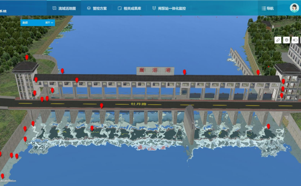
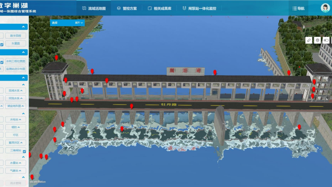
    24 May,2023
    The "1+1+3" construction model helping with the high-quality development of water conservancy informatization
  • Upgrade the water treatment of Chaohu Lake Basin with SuperMap GIS

    The “Digital Chaohu” platform is built on the basis of SuperMap GIS, using multi technologies such as 2D-3D integrated GIS, spatio-temporal big data, remote sensing image analysis, and drone aerial photography. With departmental data sharing as the core…

    05 May,2023
    Upgrade the water treatment of Chaohu Lake Basin with SuperMap GIS
  • A key step for smart water conservancy — How to build a digital twin river basin?

    The digital twin river basin is the core of smart water conservancy. The full-space digital twin technology helps to integrate the spatial data of the river basin and build the base of the platform scene in an all-around way.Relying on the self-developed …

    13 Apr,2023
    A key step for smart water conservancy — How to build a digital twin river basin?
  • Smart Water Conservancy Empowered with SuperMap GIS

    SuperMap forms a complete set of water industry information solutions, relying on the SuperMap GIS platform software and years of experience in the water industry. SuperMap provides comprehensive water solutions ranging from GIS platform software to indus…

    10 Jan,2023
    Smart Water Conservancy Empowered with SuperMap GIS
  • A Smart Digital Foundation for Water Affairs to Facilitate the Water Resources Management

    The Smart Digital Foundation for Water Affairs mainly utilizes technologies including BIM, GIS, cloud native, and micro-service. It supports the collection, storage, management and use of foundation data resources through the development of foundation dat…

    03 Jan,2023
    A Smart Digital Foundation for Water Affairs to Facilitate the Water Resources Management
  • GIS Promotes the Lake’s Digital, Intelligent and Precise Management

    As one of the five largest freshwater lakes in China, Chaohu Lake has a well-developed water system and convenient transportation. It has played a very important role in regulating and storing floods in the basin, ensuring urban water use, developing agri…

    09 Dec,2022
    GIS Promotes the Lake’s Digital, Intelligent and Precise Management
  • Natural Resource Protection Supervision Platform

    The Natural Resource Protection Supervision Platform has been used in many cities to supervise the protection of the Yangtze River waters. Based on remote sensing technology and GIS technology, build an information management service platform for the Yang…

    06 Sep,2022
    Natural Resource Protection Supervision Platform
  • Scientific Flood Control Through Water Resources Map System

    In summer, many regions suffer from heavy downpours. They have the characteristics of a large amount of accumulated rainfall, long duration, extremes, and overlapping falling areas. Flood disasters caused by heavy rainfall endanger the safety of life and …

    14 Jun,2022
    Scientific Flood Control Through Water Resources Map System
  • BIM+GIS Application in Life Cycle Digital Management of Yalong River Hydropower

    The Yalong River Basin is one of the 13 largest hydropower energy bases in China with an installed capacity of 30 million kilowatts, which is equivalent to 1.5 times of Three Gorges Power Stations. Till now, the Yalong River Basin has five downstream casc…

    06 Mar,2019
    BIM+GIS Application in Life Cycle Digital Management of Yalong River Hydropower

SuperMap GIS

  • Cloud GIS Server
  • Edge GIS Server
  • Terminal GIS for Desktop
  • Terminal GIS for Components
  • Terminal GIS for Web
  • Terminal GIS for Mobile

Stories

  • Articles
  • News
  • Magazines
  • Events

Support

  • Download & Online Help
  • Online Demonstration
  • FAQ
  • Demo Code
  • Technical Docs
  • Training Files
  • Videos
  • Trial License

Events

  • [list:pagetitle] [list:targetlink]
  • {/zzz:list}

About

  • lntroduction
  • Careers
  • Contacts
  • Suggestions

Follow Us

  • LinkedIn
  • Facebook
  • Twitter
  • Instagram
  • YouTube
© 1997-2023 SuperMap Software Co., Ltd.
  • | Privacy