SuperMap logo
  • Products

    What is GIS

    About SuperMap GIS

    Technology System

    • Big Data GIS
    • New RS Software
    • New 3D GIS
    • Geospatial AI
    • Distributed GIS
    • Cross Platform GIS

    SuperMap GIS 2024 New!!

    • Cloud GIS Server
    • Edge GIS Server
    • Terminal GIS for Desktop
    • Terminal GIS for Components
    • Terminal GIS for Web
    • Terminal GIS for Mobile

    Previous Versions

    • SuperMap GIS 2023
    • SuperMap GIS 11i(2022)
    • SuperMap GIS 10i(2021)
    • SuperMap GIS 10i(2020)
    • SuperMap GIS 10i
    • SuperMap GIS 9D(2019)
  • Solutions

    Smart City

    Natural Resource

    Land Management

    Facility Management

    Public Safety

    Natural Disasters

    Transportation

    Water Conservancy

    BIM+GIS

  • Stories
    • Articles
    • News
    • Events
    • Magazines
  • Support
    • Download & Online Help
    • Online Demonstration
    • Ask & Answer
    • Discover SuperMap GIS
    • Trial License
  • About
    • lntroduction
    • Careers
    • Contacts
    • Suggestions
 
  • English
  • 中文
  • Español
  • Français
  • ภาษาไทย
  • русский
  • Türkçe
  • Português
  • 日本語
  • 한국어
  • Indonesian
  • عربي
Land Management

Land Management Solutions

  • Home
  • Solutions
  • Land Management

Land Management

  • BIM
  • Disasters
  • Land
  • Water
  • Transportation
  • Safety
  • Facility
  • City
  • Resource
  • Measurement, Evaluation and Scenario Simulation of Land Use Spatial Conflict in the Guangdong-Hong Kong-Macao Greater Bay Area (excerpt)

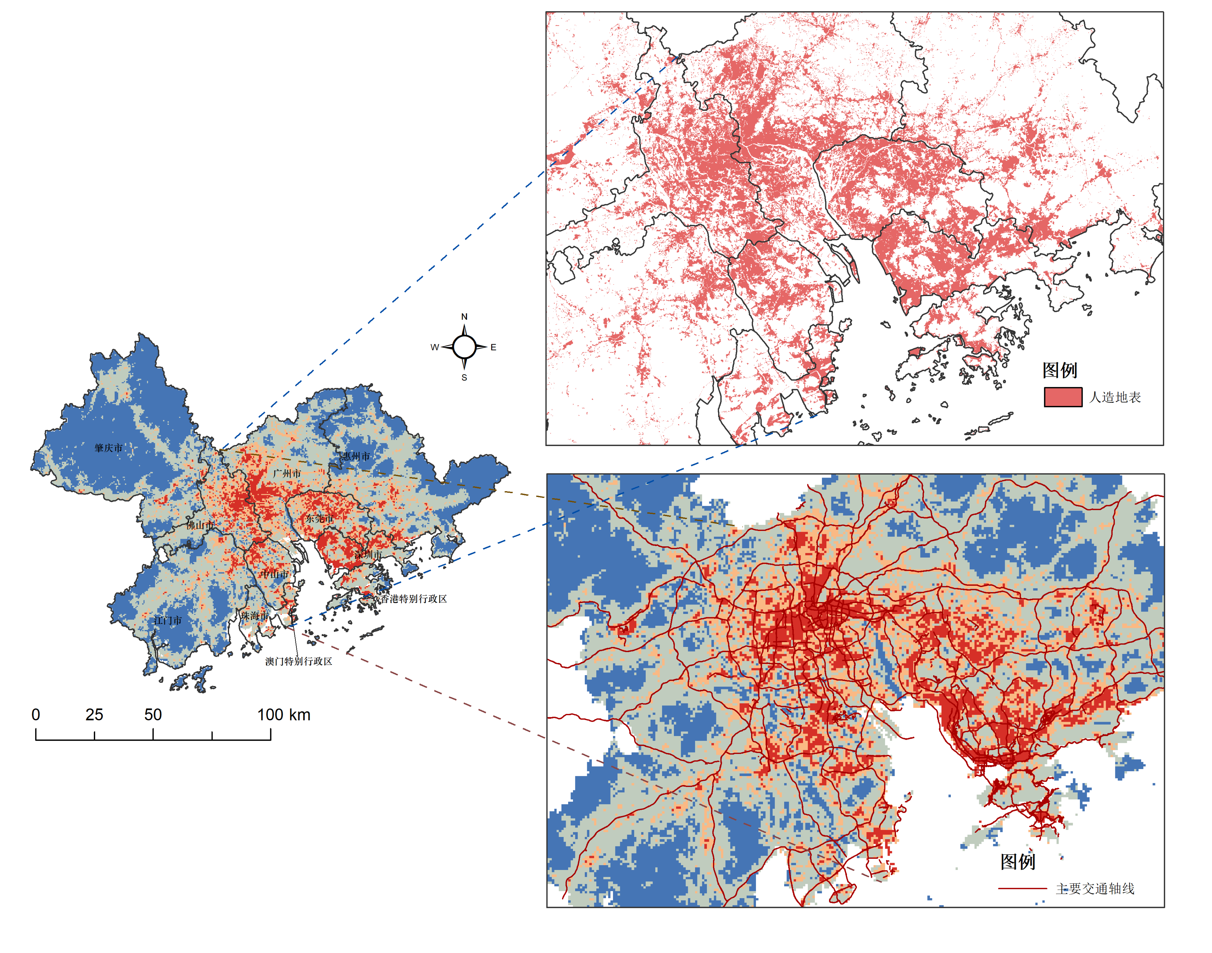
    IntroductionThis article is an excerpt from an award-winning work of the SuperMap GIS Contest.The Guangdong-Hong Kong-Macao Greater Bay Area is one of the urban agglomerations with the most developed economy, the highest population density and the highest…

    16 Feb,2023
    Measurement, Evaluation and Scenario Simulation of Land Use Spatial Conflict in the Guangdong-Hong Kong-Macao Greater Bay Area (excerpt)
  • SuperMap GIS Facilitates the Entire Process Management of Cultivated Land Resources

    To assist partners in tackling problems of low efficiency of monitoring and supervision of cultivated land and difficulty in quantity verification facing partners, SuperMap GIS comprehensively uses remote sensing, GIS, big data, AI, 2D&3D integration,…

    26 Aug,2022
    SuperMap GIS Facilitates the Entire Process Management of Cultivated Land Resources
  • Building Data Middle Platform, "Managing"​ City on One Map

    In order to regulate activities of development and land-use of territorial space in Lijiang city more effectively, local authorities collaborated with SuperMap to develop the Territorial Space Basic Information Platform and the “One-map” Territorial Spa…

    14 Apr,2022
    Building Data Middle Platform, "Managing"​ City on One Map
  • Digital Transformation of Cadastre in Mexico

    Francisco GarridoCEO, Geovirtual SA de CVhttps://www.geovirtual.info BackgroundFor years in Mexico, efforts have been made to have cadastres updated, the Federal, State Government and Municipalities have invested millions of dollars in this task. However,…
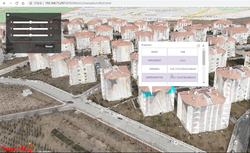
    04 Nov,2021
    Digital Transformation of Cadastre in Mexico
  • Dimension Upgrading of Cadastral Data - SuperMap Helps the Digital Construction of 3D Cadastral in Turkey

    General IntroductionTurkey 3D cadastral project is the first cadastral project that SuperMap formally participated in Europe. SuperMap developed a special vectorization tool for General Directorate of Land Registeration and Cadastre of Turk…
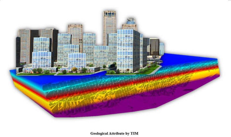
    01 Jun,2021
    Dimension Upgrading of Cadastral Data - SuperMap Helps the Digital Construction of 3D Cadastral in Turkey
  • SuperMap 3D GIS Application in Land Spatial Information Platform

    GIS technology provides strong technical support for the basic information platform of land spatial in planning, management, decision-making, service, etc. Based on the management demand of 2D and 3D integration of natural resources, the application of Su…

    05 Sep,2019
    SuperMap 3D GIS Application in Land Spatial Information Platform
  • The Urban Management Emergency Command System

    The SuperMap partner company develops the urban management emergency command and business attraction system based on SuperMap 9D. The system applies 3D true color accurate terrain sand table, geographic information, system integration and other informatio…

    24 Jul,2019
    The Urban Management Emergency Command System
  • Japan Land Information Cloud Service

    JHS, one of the leading construction suppliers, is also in the business of evaluating house, with alliance of over 20,000 companies, owning the data of foundation strength of millions of houses, covering all over Japan. And SuperMap Japan constructed the …

    19 Jun,2019
    Japan Land Information Cloud Service

SuperMap GIS

  • Cloud GIS Server
  • Edge GIS Server
  • Terminal GIS for Desktop
  • Terminal GIS for Components
  • Terminal GIS for Web
  • Terminal GIS for Mobile

Stories

  • Articles
  • News
  • Magazines
  • Events

Support

  • Download & Online Help
  • Online Demonstration
  • FAQ
  • Demo Code
  • Technical Docs
  • Training Files
  • Videos
  • Trial License

Events

  • [list:pagetitle] [list:targetlink]
  • {/zzz:list}

About

  • lntroduction
  • Careers
  • Contacts
  • Suggestions

Follow Us

  • LinkedIn
  • Facebook
  • Twitter
  • Instagram
  • YouTube
© 1997-2023 SuperMap Software Co., Ltd.
  • | Privacy