SuperMap logo
  • Products

    What is GIS

    About SuperMap GIS

    Technology System

    • Big Data GIS
    • New RS Software
    • New 3D GIS
    • Geospatial AI
    • Distributed GIS
    • Cross Platform GIS

    SuperMap GIS 2024 New!!

    • Cloud GIS Server
    • Edge GIS Server
    • Terminal GIS for Desktop
    • Terminal GIS for Components
    • Terminal GIS for Web
    • Terminal GIS for Mobile

    Previous Versions

    • SuperMap GIS 2023
    • SuperMap GIS 11i(2022)
    • SuperMap GIS 10i(2021)
    • SuperMap GIS 10i(2020)
    • SuperMap GIS 10i
    • SuperMap GIS 9D(2019)
  • Solutions

    Smart City

    Natural Resource

    Land Management

    Facility Management

    Public Safety

    Natural Disasters

    Transportation

    Water Conservancy

    BIM+GIS

  • Stories
    • Articles
    • News
    • Events
    • Magazines
  • Support
    • Download & Online Help
    • Online Demonstration
    • Ask & Answer
    • Discover SuperMap GIS
    • Trial License
  • About
    • lntroduction
    • Careers
    • Contacts
    • Suggestions
 
  • English
  • 中文
  • Español
  • Français
  • ภาษาไทย
  • русский
  • Türkçe
  • Português
  • 日本語
  • 한국어
  • Indonesian
  • عربي
Transportation

Transportation Solutions

  • Home
  • Solutions
  • Transportation

Transportation

  • BIM
  • Disasters
  • Land
  • Water
  • Transportation
  • Safety
  • Facility
  • City
  • Resource
  • Highway Construction-Management Integrated Platform

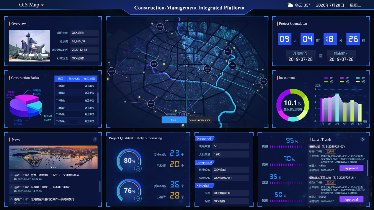
    The Highway Construction-Management Integrated Platform based on GIS fully applies mobile Internet, Internet of Things, GPS, face recognition, QR code, etc. This system runs through the entire project construction cycle and involves data collection, on-si…

    05 Sep,2022
    Highway Construction-Management Integrated Platform
  • More Efficient Traffic Management with SuperMap GIS Visualization Tools

    Based on Leaflet and SuperMap iClient JavaScript 10i (2020), an integrated green transport project of the GIS platform was developed. It was constructed through modern web technology stack. It integrated the leading open-source map library and visual char…
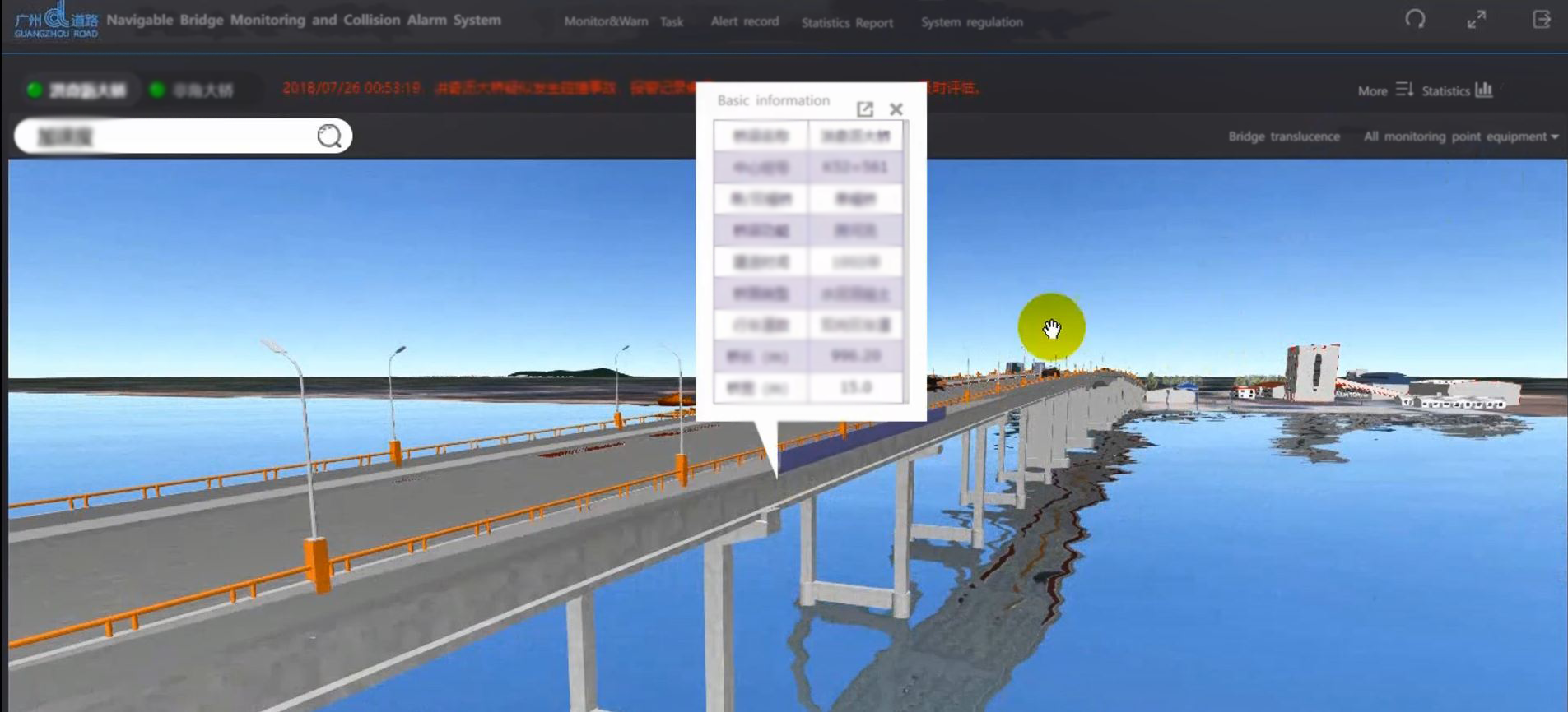
    01 Sep,2022
    More Efficient Traffic Management with SuperMap GIS Visualization Tools
  • Bridge Monitoring&Warning System

    There are 38 waterways in Guangzhou, with a navigable mileage of 585.55 kilometers. The navigable ships in the surrounding waters of Guangzhou are mainly cargo ships, and sand carriers account for more than three-quarters. Among the bridges maintained by …
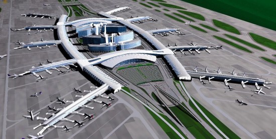
    21 Apr,2022
    Bridge Monitoring&Warning System
  • Application of GIS in fine management mode in Baiyun Airport

    Guangzhou Baiyun International Airport was the world’s 13th-busiest airport by passenger traffic, with 65.8 million passengers handled (statistics in 2017) and over 210 destinations around the world. On April 26, 2018, the opening of the T2 Terminal of B…

    07 Mar,2022
    Application of GIS in fine management mode in Baiyun Airport
  • The Application of Space Technology in Smart Highway—A Case Study of Wuxi Provincial Highway 342

    Introduction: How to automatically detect accumulated snow on the highway and get it removed in time on heavy snow days? How to remind the motorist to slow down when pedestrians are crossing the highway? How to automatically detect someone drying grain in…

    22 Feb,2022
    The Application of Space Technology in Smart Highway—A Case Study of Wuxi Provincial Highway 342
  • Prospects of 3D GIS Technology Application in Transportation Industry

    SuperMap ecological partners in the field of transportation have already explored applications in the industry based on 3D GIS technology and conducted a number of excellent application projects.

    07 Jul,2020
    Prospects of 3D GIS Technology Application in Transportation Industry
  • Applications of 3D GIS Technology in Construction of Massive Traffic Engineering

    Traffic engineering construction, especially massive traffic engineering construction, covers fields of planning, design, construction, operation and maintenance and others.

    06 Jul,2020
    Applications of 3D GIS Technology in Construction of Massive Traffic Engineering
  • New 3D GIS Technology Supports the Construction of "Digital Twins" in Transportation

    "Digital twin" is an important direction and application scenario for the development of informatization in the transportation industry, and it is also an important means of visual presentation of "smart transportation".

    03 Jul,2020
    New 3D GIS Technology Supports the Construction of "Digital Twins" in Transportation
  • The Port Management Information System

    Based on the concept of measurable and controllable management of port resources, the port management information system integrates various port resources to create port one-map

    18 Oct,2019
    The Port Management Information System
  • The Urban Rail Transit Life Cycle Information Management Platform

    At present, in the construction of urban rail transit, there are problems of large scale, long construction cycle, many involved-professions, complicated processes, many participants, coordination difficulty and security risks, which needs an information …

    11 Oct,2019
    The Urban Rail Transit Life Cycle Information Management Platform
<<< < 1 2 > >>>

SuperMap GIS

  • Cloud GIS Server
  • Edge GIS Server
  • Terminal GIS for Desktop
  • Terminal GIS for Components
  • Terminal GIS for Web
  • Terminal GIS for Mobile

Stories

  • Articles
  • News
  • Magazines
  • Events

Support

  • Download & Online Help
  • Online Demonstration
  • FAQ
  • Demo Code
  • Technical Docs
  • Training Files
  • Videos
  • Trial License

Events

  • [list:pagetitle] [list:targetlink]
  • {/zzz:list}

About

  • lntroduction
  • Careers
  • Contacts
  • Suggestions

Follow Us

  • LinkedIn
  • Facebook
  • Twitter
  • Instagram
  • YouTube
© 1997-2023 SuperMap Software Co., Ltd.
  • | Privacy