SuperMap logo
  • Products

    What is GIS

    About SuperMap GIS

    Technology System

    • Big Data GIS
    • New RS Software
    • New 3D GIS
    • Geospatial AI
    • Distributed GIS
    • Cross Platform GIS

    SuperMap GIS 2024 New!!

    • Cloud GIS Server
    • Edge GIS Server
    • Terminal GIS for Desktop
    • Terminal GIS for Components
    • Terminal GIS for Web
    • Terminal GIS for Mobile

    Previous Versions

    • SuperMap GIS 2023
    • SuperMap GIS 11i(2022)
    • SuperMap GIS 10i(2021)
    • SuperMap GIS 10i(2020)
    • SuperMap GIS 10i
    • SuperMap GIS 9D(2019)
  • Solutions

    Smart City

    Natural Resource

    Land Management

    Facility Management

    Public Safety

    Natural Disasters

    Transportation

    Water Conservancy

    BIM+GIS

  • Stories
    • Articles
    • News
    • Events
    • Magazines
  • Support
    • Download & Online Help
    • Online Demonstration
    • Ask & Answer
    • Discover SuperMap GIS
    • Trial License
  • About
    • lntroduction
    • Careers
    • Contacts
    • Suggestions
 
  • English
  • 中文
  • Español
  • Français
  • ภาษาไทย
  • русский
  • Türkçe
  • Português
  • 日本語
  • 한국어
  • Indonesian
  • عربي
BIM+GIS

BIM+GIS Solutions

  • Home
  • Solutions
  • BIM+GIS

BIM+GIS

  • BIM
  • Disasters
  • Land
  • Water
  • Transportation
  • Safety
  • Facility
  • City
  • Resource
  • Digital Airport Whole-process Solution

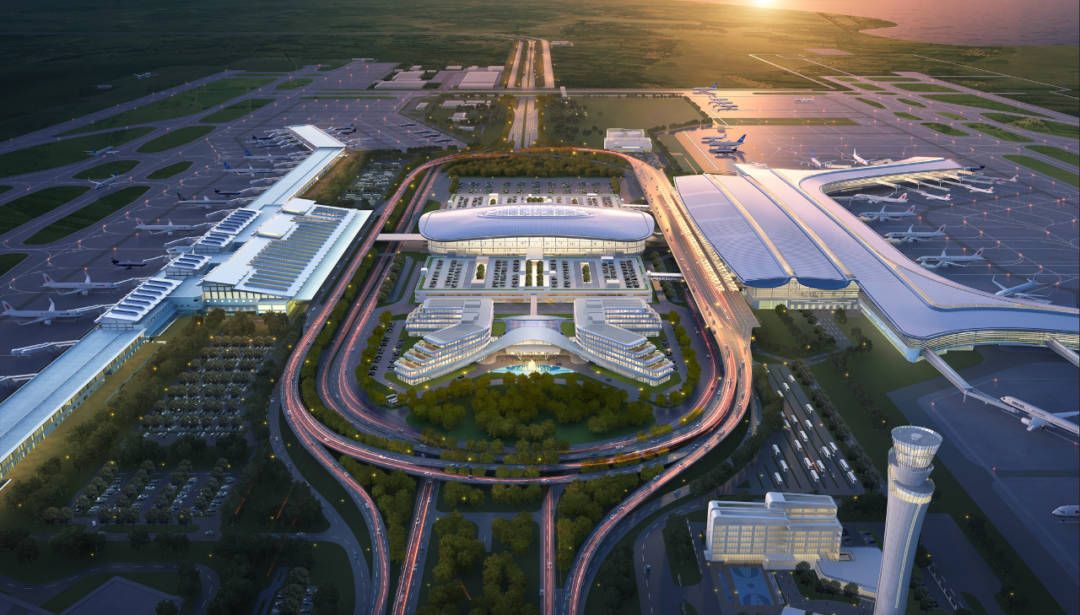
    The smart airport digital twin solution integrates cutting-edge technologies such as the Internet of Things, big data, BIM, GIS, and artificial intelligence. By establishing a complex relationship between airports in the physical world and virtual space t…
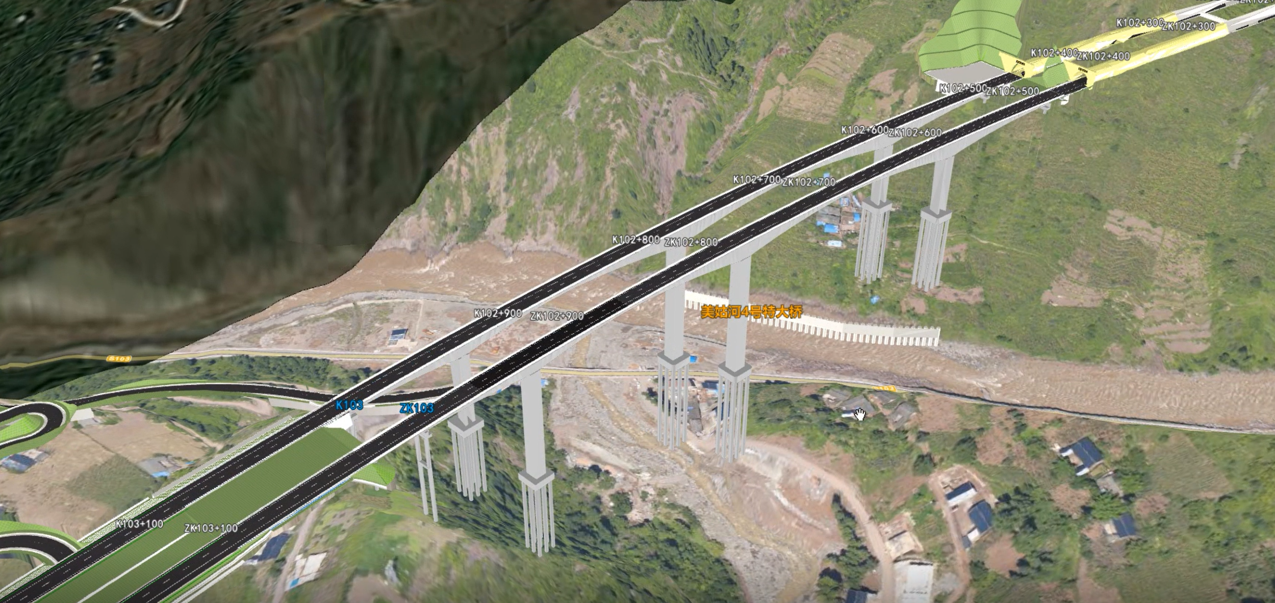
    18 Apr,2023
    Digital Airport Whole-process Solution
  • Sichuan Province Highway Construction Management BIM System

    Highways stretch in a band, and have the characteristics of long-distance, narrow width, complex terrain, diverse environments, and many types of data. Sichuan Highway Planning, Survey, Design and Research Institute adopts SuperMap multi-source data fusio…
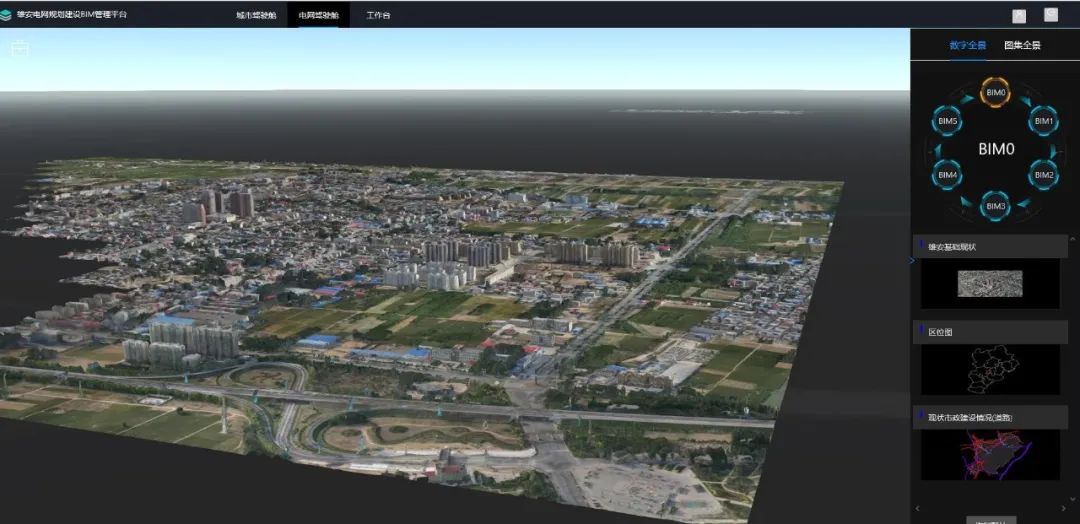
    05 Jan,2023
    Sichuan Province Highway Construction Management BIM System
  • BIM+GIS+AI, A New Way for the Planning&Construction of the Power Grid in Xiong'an!

    Introduction The BIM Management Platform for Power Grid Planning and Construction in Xiong'an (hereinafter referred to as the "platform") is a digital power grid planning and management platform that comprehensively uses BIM, GIS, big data a…
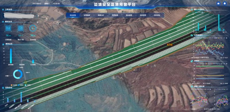
    13 Oct,2022
    BIM+GIS+AI, A New Way for the Planning&Construction of the Power Grid in Xiong'an!
  • GIS+BIM Digital Solution for the Whole Cycle of Highway Engineering

    To support data fusion and sharing, digital collaborative management, and construction-management-maintenance integration in the digital transformation of the highway, Shandong Provincial Communications Planning and Design Institute Group Co., Ltd uses th…

    30 Aug,2022
    GIS+BIM Digital Solution for the Whole Cycle of Highway Engineering
  • SuperMap Smart Airport "Digital Twin" Platform

    SuperMap shows its latest achievements of the Smart Airport “Digital Twin” platform on the recently held national “Internet + Smart Airport” summit. The flight area surveillance system, apron vehicle tracking system and VR immersive experience system …

    22 Aug,2022
    SuperMap Smart Airport "Digital Twin" Platform
  • BIM+3DGIS Makes Road Maintenance Smarter

    Chengdu Second Ring Road is an elevated highway in the southwest of China. Built and opened to traffic in May 2013, it is the only hyper channel in the city, with no traffic lights, transporting more than 200,000 people every day, which greatly alleviates…

    21 Oct,2021
    BIM+3DGIS Makes Road Maintenance Smarter
  • BIM+GIS in Highway Construction

    The integration of construction drawing design and BIM model in the management system of highway construction can perform the functions of BIM model view, design data management and view, management of site operation, site inspection, design alteration, s…
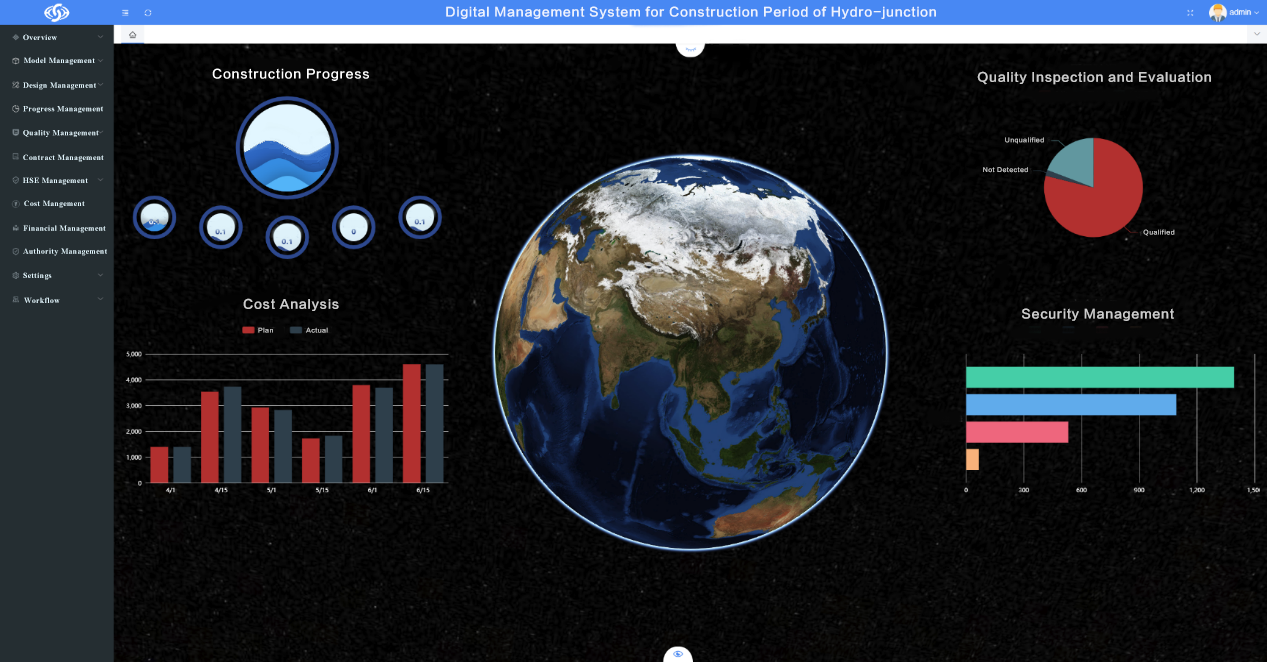
    31 Aug,2021
    BIM+GIS in Highway Construction
  • BIM+GIS in Hydro-junction Project

    YREC participated in the construction of the Narin Gol River Hydro-junction with its BIM+GIS platform integrating design and building on the basis of SuperMap GIS technology.

    20 Aug,2021
    BIM+GIS in Hydro-junction Project
  • How to Import BIM Data into GIS Platform

    Building Information Modeling (BIM for short) can be combined with GIS technology. We can use GIS software to read BIM data.

    18 Aug,2021
    How to Import BIM Data into GIS Platform
  • BIM+GIS in Urban Rail Transit System

    08 Jul,2020
    BIM+GIS in Urban Rail Transit System
<<< < 1 2 3 > >>>

SuperMap GIS

  • Cloud GIS Server
  • Edge GIS Server
  • Terminal GIS for Desktop
  • Terminal GIS for Components
  • Terminal GIS for Web
  • Terminal GIS for Mobile

Stories

  • Articles
  • News
  • Magazines
  • Events

Support

  • Download & Online Help
  • Online Demonstration
  • FAQ
  • Demo Code
  • Technical Docs
  • Training Files
  • Videos
  • Trial License

Events

  • [list:pagetitle] [list:targetlink]
  • {/zzz:list}

About

  • lntroduction
  • Careers
  • Contacts
  • Suggestions

Follow Us

  • LinkedIn
  • Facebook
  • Twitter
  • Instagram
  • YouTube
© 1997-2023 SuperMap Software Co., Ltd.
  • | Privacy